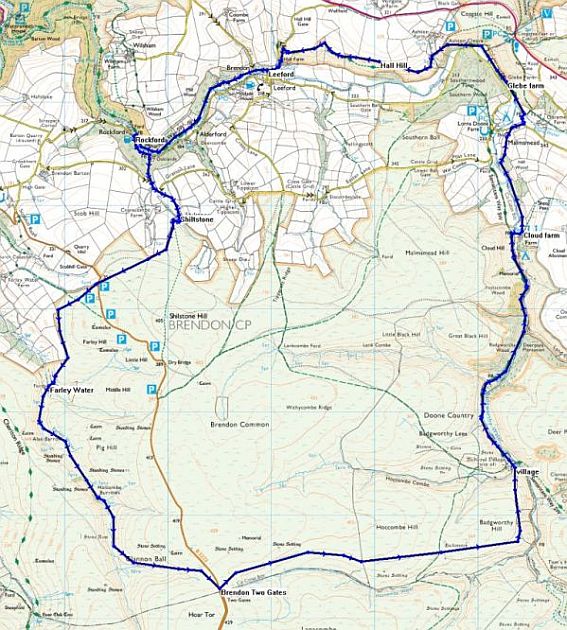
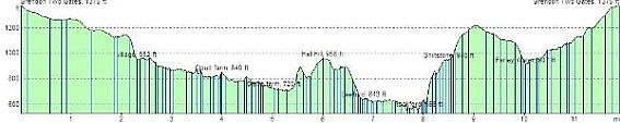
Route Distance: 11.9 miles
Estimated Time: 4:45 hours walking
Total Ascent: 2005 feet
| Leg | Name | Direction | Distance | Ascent | Time | Clock | Comments |
| 0 | Brendon Two Gates | 10:20 | Brendon Common | ||||
| 1 | village | 071°M | 2.31 Mi | 45 ft | 0:50 | 11:10 | coffee |
| 2 | Cloud farm | 005°M | 1.68 Mi | 183 ft | 0:38 | 12:05 | Badgworthy |
| 3 | Glebe farm | 357°M | 1.03 Mi | 82 ft | 0:23 | 12:28 | Malmsmead |
| 4 | Hall Hill | 282°M | 0.975 Mi | 375 ft | 0:26 | 12:55 | Ashton Cleave |
| 5 | Leeford | 269°M | 0.816 Mi | 45 ft | 0:18 | 13:15 | Lunch Leeford |
| 6 | Rockford | 247°M | 1.08 Mi | 88 ft | 0:24 | 14:10 | East Lynn |
| 7 | Shiltstone | 154°M | 0.61 Mi | 414 ft | 0:19 | 14:30 | |
| 8 | Farley Water | 220°M | 1.52 Mi | 267 ft | 0:36 | 15:05 | pause |
| 9 | Brendon Two Gates | 143°M | 1.86 Mi | 492 ft | 0:47 | 16:00 |