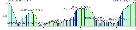
Route Distance: 11 miles
Estimated Time: 4:59
Total Ascent: 633 m
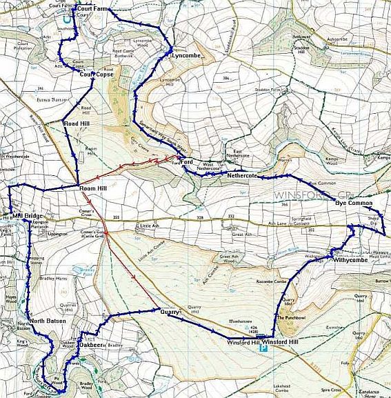
| Leg | Name, Elevation | Direction | Distance | Ascent | Time | Clock | Comments |
| 0 | Winsford Hill - 421 m | 10:30 | |||||
| 1 | Withycombe - 227 m | 040°M | 1.41 km | 0 m | 0:18 | 10:48 | |
| 2 | Bye Common - 339 m | 001°M | 1.79 km | 124 m | 0:36 | 11:24 | |
| 3 | Nethercote - 227 m | 283°M | 1.36 km | 9 m | 0:18 | 11:42 | Coffee Photo |
| 4 | Lyncombe - 242 m | 335°M | 2.41 km | 55 m | 0:37 | 12:30 | |
| 5 | Court Farm - 248 m | 296°M | 1.35 km | 41 m | 0:22 | 12:52 | |
| 6 | Court Copse - 343 m | 177°M | 1.06 km | 104 m | 0:24 | 13:16 | lunch? |
| 7 | Road Hill - 363 m | 197°M | 852 m | 32 m | 0:14 | 13:50 | |
| 7a | Room Hill - 375 m | 166°M | 783 m | 19 m | 0:12 | 14:03 | |
| 8 | Mill Bridge - 265 m | 247°M | 1.13 km | 0 m | 0:14 | 14:18 | Photo |
| 9 | North Batson - 247 m | 170°M | 1.38 km | 33 m | 0:21 | 14:40 | |
| 10 | Oakbeer - 259 m | 115°M | 1.83 km | 52 m | 0:29 | 15:10 | |
| 10a | Quarry - 380 m | 067°M | 1.16 km | 120 m | 0:27 | 15:37 | |
| 11 | Winsford Hill - 421 m | 106°M | 1.26 km | 42 m | 0:21 | 16:00 |